martedì 25 dicembre 2012
mercoledì 25 luglio 2012
SUGGESTED MUSIC


.This Week’s Sky at a Glance, March 10 – 18
This Week's Planet Roundup
Raffaello Lena in Rome has been imaging Venus as it wanes in phase and enlarges in size, using a 7-inch Maksutov-Cassegrain scope. He plans to continue right up to Venus's conjunction 8° north of the Sun.
THE TRANSFORMATION OF VENUS, CONTINUED: On March 25th, Venus will pass almost directly between Earth and the sun--an event astronomers call "inferior solar conjunction." As Venus approaches the sun, the planet is turning its night side toward Earth, reducing its luminous glow to a thin sliver. Astrophotographer Raffaello Lena of Rome, Italy, has been monitoring the transformation:
"I've just added an image from March 10th to this composite," says Lena. "It clearly shows the transformation of Venus to a skinny crescent."
You don't need such a large telescope to see the shape of Venus. Even ordinary binoculars will show the crescent. Amateur astronomers are encouraged to monitor Venus in the lead-up to inferior conjunction. In the nights ahead, the crescent of Venus will become increasingly thin and circular. The horns of the crescent might actually touch when the Venus-sun angle is least on March 25th.
THE TRANSFORMATION OF VENUS: On March 25th, Venus will pass almost directly between Earth and the sun--an event astronomers call "inferior solar conjunction." As Venus approaches the sun, the planet is turning its night side toward Earth, reducing its luminous glow to a thin sliver. Astrophotographer Raffaello Lena of Rome, Italy, has been monitoring the transformation:
"The progression of the crescent as Venus approaches inferior conjunction is clear," says Lena. "I took these pictures using an 18 cm (7 inch) Mak Cassegrain telescope."
You don't need such a large telescope, however, to see the shape of Venus. Even ordinary binoculars will show the crescent. Amateur astronomers are encouraged to monitor Venus in the lead-up to inferior conjunction. In the nights ahead, the crescent of Venus will become increasingly thin and circular.
TWINKLE, TWINKLE, CRESCENT VENUS: Like the Moon, Venus has phases, and right now it is a beautifully slender crescent. On March 17th, Italian astronomer Raffaello Lena used a small telescope to track Venus down to the horizon as it set in the evening sky of Rome. He recorded a beautiful example of atmospheric turbulence distorting the curved lines of the second planet
This kind of scintillation is normally reserved for pinpoint objects like distant stars. Venus is so thin, it's doing it too.
| ||||||
|


An unexpected transit
 |
| Rafaello Lena, of the GLR Group in Rome passes along this serendipitous interruption of his efforts to record Earth atmosphere-grazing Perseid meteors and perhaps another lunar impact, captured at 1945 UT, Monday, August 12 . An aircraft, and easily "identified flying object," transits the evening Moon. Still 40 hours shy of its Quarter phase, the Moon was 377,200 km away as the terminator swung over central Mare Serenitatis and the Southern Highlands, sunrise over the 1972 landing site of Apollo 16. |
OUTSIDE

image by Raf Lena, Rome, Italy
Most interest in Petavius is focused on its interior, with the giant trough, squiggly rilles, dome and pyroclastics - all characteristics of a floor-fractured crater. This image draws attention to things beyond the rim. Most impressively, the smooth material to the right (south) is very extensive, filling every low spot for a distance of about 60 km. This is considered to be impact melt, but it is relatively ancient since Petavius was mapped by the US Geological Survey folks as Lower Imbrian - about 3.8 billion year old. I've always said that the melt just north of Theophilus was the easiest to see with a telescope but this melt covers a larger area. I assume that the concentration of melt on the south means that the projectile that formed Petavius came from the north at a low angle. This would imply that Petavius' peculiarly wide rim on the south is due to an oblique impact but the rim is different than any other down range rim, isn't it? Palitzsch and its valley to the east/southeast of Petavius are oddities. Probably they are all one feature, a basin secondary crater chain. The valley is about radial to the Crisium Basin, but I would expect the largest crater to be nearest the source, but it isn't. Finally, we can note the battered Snellius Valley, from lower right to upper right, which is a basin secondary chain from Nectaris. About half of the floor of Snellius iself has been covered by ejecta from nearby Stevinus, an indignity it will have to live with for more billions of years.
Chuck Wood
Technical Details
Dec 28, 2011, 16:24 UT. Mak-Cass 18 cm.
Related Links
Rükl plate 59
OUTSIDE
image by Raf Lena, Rome, Italy
Most interest in Petavius is focused on its interior, with the giant trough, squiggly rilles, dome and pyroclastics - all characteristics of a floor-fractured crater. This image draws attention to things beyond the rim. Most impressively, the smooth material to the right (south) is very extensive, filling every low spot for a distance of about 60 km. This is considered to be impact melt, but it is relatively ancient since Petavius was mapped by the US Geological Survey folks as Lower Imbrian - about 3.8 billion year old. I've always said that the melt just north of Theophilus was the easiest to see with a telescope but this melt covers a larger area. I assume that the concentration of melt on the south means that the projectile that formed Petavius came from the north at a low angle. This would imply that Petavius' peculiarly wide rim on the south is due to an oblique impact but the rim is different than any other down range rim, isn't it? Palitzsch and its valley to the east/southeast of Petavius are oddities. Probably they are all one feature, a basin secondary crater chain. The valley is about radial to the Crisium Basin, but I would expect the largest crater to be nearest the source, but it isn't. Finally, we can note the battered Snellius Valley, from lower right to upper right, which is a basin secondary chain from Nectaris. About half of the floor of Snellius iself has been covered by ejecta from nearby Stevinus, an indignity it will have to live with for more billions of years.
Chuck Wood
Technical Details
Dec 28, 2011, 16:24 UT. Mak-Cass 18 cm.
Related Links
Rükl plate 59
QUIET CRISIUM

image by Raf Lena
Crisium is probably the most attractive lunar maria because of its separation from all other maria, oval shape, and dramatic bounding bluffs. But the mare surface itself is free of many imposing craters, with only the two P craters, Picard and Pierce, (and little Swift) being relatively young but are are small and none have rays. The three largest craters, Yerkes, Lick, and Einmart C (upper center) are all on the bench of shallow lava that hugs the shoreline. These are older craters whose walls were breeched and floors covered by mare lavas. Yerkes - the bottommost crater - appears to also be a floor-fractured crater, whose floor was domed up and perhaps split open. The mare ridge on the western side of Crisium is a fault with the inner side a couple hundred meters lower than the bench. Actually the floor of the basin is much deeper - estimates are the lava is 1.9 km thick - explaining why the earlier craters that must have formed on the basin's floor are no longer visible.
Chuck Wood
Technical Details
Dec 28, 2011, 16:40 UT.
Related Links
Rükl plate 26
SILVER, GOING FOR GOLD

image from Selenology Today
The silver anniversary of anything is a significant achievement of perseverance, and a reason to publically celebrate. The Geologic Lunar Research group started a new lunar journal, Selenology Today, in 2006, and now the 25th issue has appeared. Editor Raf Lena and the editorial board of Marie Teresa Bregante, Jim Phillips, Christian Wöhler and I have defied the odds by continuing to publish issue after issue, each containing scientifically new results. These same people have published a series of papers in professional journals that have become the standard works on lunar domes. And ST has provided an avenue for others – including a number of LPOD contributors - to see in print their first scientific publication about the Moon. I congratulate the ST editorial team and encourage LPOD readers to undertake some research and join the ST family of contributors. I look forward to the next 25 issues.
Chuck Wood
Download free issues of Selenology Today!
DOME STUDENTS

image by GLR click for full-sized version
The GLR is a group of dedicated amateurs interested in the study of domes and other lunar surface features visible from Earth. Our work often finds its way into scientific journals. This poster summarizes our study of two domes near Doppelmayer, which were examined in a recent paper published in Planetary and Space Science, by the GLR group. Due to the fact that Dome 1 is located right on the boundary between hummocky terrain and a mare pond, lateral mixing of mare and highland soils is a much more natural explanation for the observed spectral signature. Dome 1 appears to be smooth with a shallow and elongated fissure on the summit. For dome 2, we found that it is a typical effusive mare dome, given its spectral and morphometric properties and inferred rheologic parameters. In the Lunar Orbiter image the dome appears to have a smooth surface with an out flow channel or chain of vents and linear rilles. An estimation of the dimensions of the feeder dikes suggest that their source regions were located below the lunar crust. In a new and recent image it is possible see the resolved domes in Doppelmayer (see attachment) and the summit elongated fissure for dome 1 but also the central elusive rille for dome 2. It is compared with Lunar Orbiter frame.
Image and commentary submitted by Raffaello Lena
Editor's note: Chuck Wood is on vacation. Today's LPOD has been contributed by a member of the-Moon Wiki. You can do the same while we await Chuck's return.
Technical Details
- Photos taken by Raffaello Lena (GLR group) with a Maksutov Cassegrain 18 cm f/15 and Lumenera LU 075 M - Rome (Italy). Additional details on image.
Related Links
- Rükl plate 52
- R. Lena, C. Wöhler, J. Phillips, M. Wirths, M. T. Bregante. Lunar domes in the Doppelmayer region: Spectrophotometry, morphometry, rheology, and eruption conditions. Planetary and Space Science, vol. 55, pp. 1201-1217, 2007. This paper also available as a PDF download (1.3 MB)
- Selenology Today a free on-line magazine of lunar studies published by the GLR
- Earlier LPOD: Doppelmayer Surprises
- Index of past LPOD's
CLASSIC GEOLOGY

image by Raffaello Leno, Rome, Italy
When looking at Raf's dramatic image I notice a number of intriguing geologic features. First is the buried continuation of the Fresnel Rille at bottom center under the lavas to its north. The straight edge of the textured terrain south east of shadowed Autolycus suggests that the lava-covered region subsided along a fault, but the lava isn't too thick otherwise the rille would not be visible at all. Another intriguing feature is the flattened mound of older lavas that the Theaetetus Rilles cut. This mini-plateau is bounded on the west by a curved falloff in elevation marked by a partially shadowed shallow slope. Or perhaps the shadow is just the eastern slope of a gentle trench. Perhaps a detailed look at LRO atimetry data will reveal what is really happening here. A third intriguing feature is the secondary crater chain from Aristillus that passes south of Theaetetus. The craters near the end of the chain touch each other, very much like the much larger basin secondary crater chains on the west side of Orientale. Such continuous secondary crater chains is not the way most chains are, but some are, including this one. These and other features do attract attention but the best thing about this scene is its classic, emotional power. This is the Moon we love to observe.
Chuck Wood
Technical Details
April 10, 2011, 20:03 UT. Mak-Cass 18 cm + Lumenera LU076M.
Related Links
Rükl plate 12
THROWING OUT THE WASHBOWL WITH THE BATH WATER

LRO WAC image processed by Raffaello Lena, Roma, Italia; insert drawing from Wilkins 1955
Percy Wilkins probably never imagined that his drawings made in the 1950s would someday be compared to high resolution spacecraft images, but it has happened. Wilkins and Moore (The Moon, p 228) state that on 3 April 1952 they observed the crater Cassini A with the 33" Meudon refractor. In the Journal of the British Astronomical Association, Wilkins uses essentially the same drawing (shown here) to illustrate his observation of Cassini and A, reportedly made with the 33" on April 21, 1953. Cassini A is the largest crater within Cassini. In The Moon this description appears of a feature inside A: "a white, very shallow crater within which is a most minute central pit, the whole strongly resembling a 'Washbowl', and named accordingly." The JBAA article says the shallow crater is about 2 miles wide. This high Sun LRO WAC image processed by Raf beautifully reveals the inside of Cassini A. There is no 2 mile wide crater inside A where Wilkins drew one, but there are three small ridges/ hills which perhaps could look like a shallow crater under the lighting conditions depicted in the drawing, and with less resolution than afforded by the spacecraft image. The "most minute pit" does not exist either, but the shadow from the topmost hill might have suggested a pit. For nearly 60 years amateur literature has been awash (sorry) with discussions and explanations of the illusive washbowl. In reality, the washbowl and its minute pit do not exist, but even if they did they would be of no geologic significance. Much more interesting is the reason for the elongated shape of Cassini A, which Raf and his colleagues earlier explained as a closely-spaced double impact. That is a reasonable hypothesis, or it possibly could have formed as an oblique impact. The origin of Cassini A is worth discussing.
Chuck Wood
Related Links
Rükl plate 12
CLASS B CONE

LRO image excerpt from April 9 LPOD
A recent LPOD image from LRO showed a small elongated volcano cone east of Flamsteed. I determined it's position (42.42° W and 4.86° S), and using the image time of 2010-01-10 UT 16:14:44, determined that the corresponding solar altitude above the cone is 9.94°. The image was then imported and rotated until the axes of the shadows appeared horizontal. The scale of the image corresponds to 0.0738 km per pixel computed based on the diameter of the crater Flamsteed of 20 km. The diameter for the elongated cone is 2.28 km (North South direction) x 0.74 km (East-West direction). Based on measurements of the shadow length (7.7 pixels corresponding to 0.568 km), the height of the flank of the lunar cone amounts to 98 m ± 10 m. The slope is computed to be 4.9° for the steepest part of the cone. The shape of the cone fits the class B of cinder cones in the San Francisco Volcanic Field in northern Arizona in the scheme used by Breed (1964 - Morphology and lineation of cinder cones in the San Francisco volcanic field. Museum of northern Arizona bulletin N.40, 65-71).

Raffaella Lena
 Modifica
DOME CLOSEUP

LRO WAC image processed byRick Evans (I think)
Milichius (bottom right) is a standard small impact crater 12 km in diameter, but it has been a valuable guidepost for the nearby prominent - at least as much as they can be - dome. Named Milichius Pi on the System of Lunar Craters charts, this feature has been known at least since 1931 when Elger called it a dome. It was one of the early
features studied by the Geologic Lunar Research group who labelled it M12 and found it to be 9.7 km in diameter and about 230 m high. It has a very common dome shape, a flattened plateau surrounded by acarp (but still a relatively low slope), with a rimless crater on top. To the upper left is another common type of dome. This seems to have a more gentle continuous slope and less flattening across the top. Possibly it too is circled by a scarp, but if so it has been covered by what appears to be subsequent lava flows. This dome is crossed by a rille which has two or three
volcanic cones at its northern end. GLR also studied the largest cone, which they call MC1, and found it to be 1.8 km wide and 61 m high. These cones probably formed by a slight escape of magma from the underlying dike that wedged apart this piece of crust, causing the rille to form.
Chuck Wood
Related Links
Rükl plate 30
Consolidated Lunar Dome Catalogue
COLOR TOLD TALES

image from Selenology Today
For many years amateur observers of the Moon made sketches and took photos. Other than special interest programs of the ALPO and the BAA there was little scientific analysis of what they saw. The Geological Lunar Research group has changed that. SInce issue #1 of GLR's Selenology Today they have promoted serious scientific investigation of the Moon. Much of the earlier work concerned topographic studies of domes and faults, and more recently they have developed techniques and software for multi-spectral mapping. Now Rick Evans with help by Raf Lena and Christian Wöhler, has published a practical manual so that others can follow their lead in extracting compositional information from Clementine and Selene data. But be warned, spectral mapping requires learning about minerals and rocks whose terminology is baffling until it becomes familiar And the processing of images to deduce compositions requires many careful steps. But this is just the sort of process that many technically exuberant amateurs excel at. Congratulations to Rick, Raf and Christian!
Chuck Wood
A FLASH IN THE NIGHT

ST cover image from Geologic Lunar Research Group
I remember reading a biography of the 19th century geologist Charles Lyell whose scientific articles would often be published within a few days of when he completed writing them. Now it commonly takes 6-12 months for a paper to be peer reviewed and get through the editorial process before being published. But not for Selenology Today, the very high level lunar journal published by the Geologic Lunar Research Group. On Feb 17 GLR released a special issue of ST reporting on simultaneous video observations of a lunar impact flash that occurred Feb 11. This event was observed independently by two people 13 km apart, and the flash appears on 3 to 4 frames of each of their videos. It will be interesting to compare LRO high resolution images of the impact area from before and after the event. Check out the issue for the details.
Chuck Wood
Related Links
NASA's Lunar Impact Monitoring Program
ST, NOT SJ

eight recent issues of Selenology Today
From 1879 to 1883 William Birt, Edmund Neison and other lunar observers conducted systematic studies of the Moon. Physical copies of the five volumes of their Selenographical Journal are now rare. During the last five years a modern group of amateurs has created another lunar journal of their work. The 17th issue of Selenology Today has just appeared, adding 80 pages of careful studies and analyses to the lunar literature. The papers included in ST use modern approaches to determine material compositions, elevations, slopes and geologic history. Two of the leaders of ST - Raf Lena and Christian Wohler - have also been publishing excellent peer-reviewed articles in professional planetary science journals, demonstrating the level of expertise that has developed within ST. ST does share one characteristic with SJ - neither was/is published as part of a journal that was/is widely distributed in libraries so ST may be as hard to find 100 years from now as SJ is today. Or perhaps Google will succeed in digitizing everything - perhaps even books that haven't been written yet - and all will be forever available anytime, anywhere. But I will miss the smell of old books, and feeling the pages that readers 100 years earlier had touched.
TESTING TLPs

images and simulations by Raf Lena, Rome, Italy. You may need to adjust your monitor to see the faint spots of the floor.
Transient Lunar Phenomenon are a little like flying saucer reports. Few people see them, they are rarely confirmed, and there is great uncertainty of their reality. Raf Lena and colleagues in the Lunar Research Group have previously observed a few historic TLP reports, finding that when the exact same illumination conditions (including librations) occur, that the TLP reappears. This proves that these particular TLPs are simply fleeting illuminations of a crater's floor that occur only with specific conditions. No levitating dust, gaseous discharges or other mysteries are required. The problem is that it may take an entire 18 year saros cycle for an exact repeat observation of any specific reported TLP, and there may be clouds on the night of interest. But now two advances in technology permit every entry in the TLP catalogs to be examined under conditions identical to each observation. The recent release of the Kaguya digital elevation model (DEM), which is based on more than 6 million laser pings of the surface, provides a detailed enough map to use ray tracing to recreate any illumination. Jim Mosher has updated the LTVT program so that it easily reads the DEM and rotates the virtual surface to exactly the lighting conditions at any instant. Raf has used this capability to compare actual observations with a DEM-LTVT simulation for two events in Ptolemaeus. The right image set has a drawing Raf made in 2003 during an exact repeat of a classic Ptolemaeus haze report. The simulation shows that the crater rim allows a swath of illumination to fall of the floor exactly as observed. The left image set shows that another temporary illumination of the floor can be shown by the simulation to be due to the geometry of rim and floor. This new capability will quickly show which classic TLPs are repeatable, and which can not be explained that way. Who says we can't resolve mysteries?
Chuck Wood
Related Links
Rükl plate 44
martedì 24 luglio 2012
DON'T BURP

image by Raffaello Lena, Rome, Italy
The first bite from the Planetary Energy Processor has gnawed into the eastern limb of the Moon. The material removed is converted to mountain-sized pellets and the mass transformed directly into energy. Although Einstein's equation suggests that the 7.36 × 10^22 kilograms of the Moon will produce an unimaginable quantity of energy, it actually will last only three years, what with the voracious energy consumption of Earth's 27 billion inhabitants and the major terraforming project on Mars. There was some reluctance to remove the Moon, especially from romantics and the small LPOD cult, but deep sky observers were able to convince the dominant Earth is China Federation that the Moon had served its purpose and that this would be an accidental way to eliminate the pesky rebel cities buried under so many of the crater floors.
Chuck Wood
Technical Details
Details on image - read quickly before PEP's next bite.
SUGGESTED MUSIC

01 February 2015
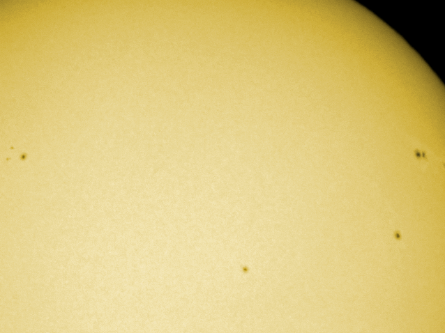
The huge sunspot 2192

By Raffaello Lena( http://glrgroup2.blogspot.it/ )
Huge sunspot in October 2014. Images of the mosaic taken with a TMB 13 cm refractor rom Rome Italy.

18 April 2015
Lunar volcanos at the terminator

By Raffaello Lena( http://glrgroup2.blogspot.it/ )
Lunar volcanoes at the terminator near Hortensius and Milichius. The image displays also
Copernicus and Stadius - February 28 2015 from Rome Italy and a Mak Cassegrain 18 cm
18 May 2015
Sun eclipse March 20 2015

By Raffaello Lena
Here my first at maximum contact from Rome 09:32 UT.
it is a mosaic of 6 shots taken with a TMB 13 cm refractor.
Note the irregular lunar limb against the solar surface
31 July 2015

Mosaic with images taken with TMB 13 cm refractor and Mak Cassegrain 18 cm from Rome.

Many of the oddities are concentrated in Oceanus
Procellarum, including Rümker, the Aristarchus Plateau, Schröter's Valley, and
the Marius Hills. Across the Moon most familar small
volcanic cones are standard domes like those near Kies, Hortensius and Cauchy. These were constructed by eruptions of lava
flows from a central vent. Because the lavas were fluid they didn't build steep
hills - normal This Week’s Sky at a Glance, March 10 – 18
This Week's Planet Roundup
Raffaello Lena in Rome has been imaging Venus as it wanes in phase and enlarges in size, using a 7-inch Maksutov-Cassegrain scope. He plans to continue right up to Venus's conjunction 8° north of the Sun.
THE TRANSFORMATION OF VENUS, CONTINUED: On March 25th, Venus will pass almost directly between Earth and the sun--an event astronomers call "inferior solar conjunction." As Venus approaches the sun, the planet is turning its night side toward Earth, reducing its luminous glow to a thin sliver. Astrophotographer Raffaello Lena of Rome, Italy, has been monitoring the transformation:
"I've just added an image from March 10th to this composite," says Lena. "It clearly shows the transformation of Venus to a skinny crescent."
You don't need such a large telescope to see the shape of Venus. Even ordinary binoculars will show the crescent. Amateur astronomers are encouraged to monitor Venus in the lead-up to inferior conjunction. In the nights ahead, the crescent of Venus will become increasingly thin and circular. The horns of the crescent might actually touch when the Venus-sun angle is least on March 25th.
THE TRANSFORMATION OF VENUS: On March 25th, Venus will pass almost directly between Earth and the sun--an event astronomers call "inferior solar conjunction." As Venus approaches the sun, the planet is turning its night side toward Earth, reducing its luminous glow to a thin sliver. Astrophotographer Raffaello Lena of Rome, Italy, has been monitoring the transformation:
"The progression of the crescent as Venus approaches inferior conjunction is clear," says Lena. "I took these pictures using an 18 cm (7 inch) Mak Cassegrain telescope."
You don't need such a large telescope, however, to see the shape of Venus. Even ordinary binoculars will show the crescent. Amateur astronomers are encouraged to monitor Venus in the lead-up to inferior conjunction. In the nights ahead, the crescent of Venus will become increasingly thin and circular.
TWINKLE, TWINKLE, CRESCENT VENUS: Like the Moon, Venus has phases, and right now it is a beautifully slender crescent. On March 17th, Italian astronomer Raffaello Lena used a small telescope to track Venus down to the horizon as it set in the evening sky of Rome. He recorded a beautiful example of atmospheric turbulence distorting the curved lines of the second planet
This kind of scintillation is normally reserved for pinpoint objects like distant stars. Venus is so thin, it's doing it too.
01 February 2015
The huge sunspot 2192

By Raffaello Lena( http://glrgroup2.blogspot.it/ )
Huge sunspot in October 2014. Images of the mosaic taken with a TMB 13 cm refractor rom Rome Italy.
18 April 2015
Lunar volcanos at the terminator

By Raffaello Lena( http://glrgroup2.blogspot.it/ )
Lunar volcanoes at the terminator near Hortensius and Milichius. The image displays also
Copernicus and Stadius - February 28 2015 from Rome Italy and a Mak Cassegrain 18 cm
18 May 2015
Sun eclipse March 20 2015

By Raffaello Lena
Here my first at maximum contact from Rome 09:32 UT.
it is a mosaic of 6 shots taken with a TMB 13 cm refractor.
Note the irregular lunar limb against the solar surface
Saturn oppositions

By Raffaello Lena
My last image of Saturn taken on June 5 2015 is assembled with my previous saturn images in the cicle of the life FROM 2006 to 2015.Mosaic with images taken with TMB 13 cm refractor and Mak Cassegrain 18 cm from Rome.
Raffaello Lena, of the GLR Group in Rome, has documented the simultaneous observation of the exceedingly transitory flash of an impact on the Moon by three observers, using four telescopes equipped with CCD cameras, from three separate locations.
"On August 1, 2013 at 02:21:55.7 UT, we observed a small meteoroid impact on the Moon's surface. The kinetic energy transformed into heat caused a brief and intense flash detected simultaniously in telescopes operated by R. Lena, A. Manna and S. Sposetti.
"The simultaneity of the flash observations, at the same position on the lunar surface strongly indicate the flash is unlikely to be mistaken for anything other than an impact."
The event was recorded by Raffaello Lena in Rome Italy, Andrea Manna in Cugnasco, Switzerland, and by Stefano Sposetti in Gnosca, Switzerland. The two observatories in Switzerland were separated by 10 km while Lena in Rome was 558 km from Gnosca.
The meteoroidal lunar impact detected on August, 1, 2013 at 02:21:55.7 UT was simultaneously recorded by four independent video recordings. The duration of the flash corresponds with 0.08 seconds peaked in a brightness of 8.3 ± 0.7 magnitude. Synchronicity of the documenting images and related files was verified using GPS time inserters (KIWI-OSD) and an Atomic Clock Synchronization protocol.
The coordinates of the flash were determined to 73° (± 4°) East, 27° (± 3°) North, near the crater Seneca C.
"The flash probably corresponds to an α-Capricornids meteor stream, exhibiting favorable geometry at time of impact."
A report of the coordinated observing session is published in Selenology Today, HERE, and an Adobe pdf file with the particular of the event and observing session can be also downloaded HERE.
In addition, Lena reports, "some animations and data, are also presented on my website:http://lunarimpact2.blogspot.it/ .
Related Posts:
Earth's Nightlight (June 26, 2013)
March of Time Paces Changes on the Lunar Surface (May 21, 2013)
LROC team identifies a new lunar crater (July 28, 2010)
The Lunar Geminids (December 10, 2009)
Impact Gap in the Moon's Southern Highlands? (May 22, 2008)
CAUGHT ONE!
| |||||||
|


BUMPS IN THE NIGHT
image by Raf
Lena, Rome, Italy
The Moon has of thousands of observable craters, hundreds of rilles, domes and mare ridges, and a handful of unique features.
The Moon has of thousands of observable craters, hundreds of rilles, domes and mare ridges, and a handful of unique features.
domes have slopes of only a few degrees. But something makes the steeper-sided cones in the Marius Hills. If you look closely at Raf's image you may notice that the cones are quite irregular in shape. For some, the bottom has a gentle slope and the top is steeper.
Others have an associated hilly flow. These observations suggest that the Marius Hills had different origins than the generic dome. There is spectroscopic evidence for ash at many of the cones so it is likely that explosive eruptions may have built lunar equivalents to terrestrial cinder cones. The hilly material surrounding some of the cones is probably viscous lava flows. The gentle slopes at the base of other hills may be due to normal dome lavas that are more fluid. So there are two unique features of the Marius Hills - there is a great concentration of volcanoes, and they have more pyroclastics than volcanoes elsewhere on the Moon. Asking why to both of these questions is reasonable, answering is hard.
Chuck Wood
Technical Details
Nov. 25, 2012, 23:28 UT. Mak-Cass 18 cm + Lumenera LU 075M.

Tuesday, August 13, 2013
An unexpected transit
|
| Rafaello Lena, of the GLR Group in Rome passes along this serendipitous interruption of his efforts to record Earth atmosphere-grazing Perseid meteors and perhaps another lunar impact, captured at 1945 UT, Monday, August 12 . An aircraft, and easily "identified flying object," transits the evening Moon. Still 40 hours shy of its Quarter phase, the Moon was 377,200 km away as the terminator swung over central Mare Serenitatis and the Southern Highlands, sunrise over the 1972 landing site of Apollo 16. |
April 11, 2012
REBIRTH

image by Raf Lena, Rome, Italy
Kipuka is a lovely word that hardly anyone has heard of unless they've been to Hawaii. A kipuka is a high standing remnant of an earlier terrain now surrounded by lava flows. Raf has documented a classic example of a lunar kipuka, this slight rise (rising about 500 m over a radius of roughly 25 km) cut by the Opelt Rille at the boundary of maria Cognitum and Nubium. With lower resolution there isn't much difference between the rise and the surrounding, so it could be a large dome. But it is clear in Raf's image and the LRO excerpt at left that the rise is more fractured and more pitted with small craters. It isn't the same material - its older. The fact that the rise is cut by fractures suggests that its elevation may have resulted from it being domed upward when it was young. Its a kipuka now, but maybe it was a dome (or swell) before.
Chuck Wood
Related Links
Rükl plate 42
Later Addition
After posting this I came across an image released by NASA's Earth Observatory of young lava flows in Ethiopia. Part of it looked very similar to the kipuka described in today's LPOD.

See the EO posting for details.
Wednesday, March 4, 2009
Raffaello Lena - GLRP & Selenology Today #13
 From
left to right, South to North. A very highly scaled section of a much
larger 12.6 cm comparative polarity image of the Near Side portion of
the Lunar South Pole, just above the rim of abyssal 19 kilometer wide
Shackleton (lower left), future notional site of Armstrong Station, the
American portion of the semi-permanently manned lunar outpost presently
in the federal budget. Malapert Mountain, on the Right, has been the
notional site of every possible multi-purpose lunar outpost imaginable,
and for good reason. As on Earth, so it is on the Moon. Real Estate is
"location, location, location."
From
left to right, South to North. A very highly scaled section of a much
larger 12.6 cm comparative polarity image of the Near Side portion of
the Lunar South Pole, just above the rim of abyssal 19 kilometer wide
Shackleton (lower left), future notional site of Armstrong Station, the
American portion of the semi-permanently manned lunar outpost presently
in the federal budget. Malapert Mountain, on the Right, has been the
notional site of every possible multi-purpose lunar outpost imaginable,
and for good reason. As on Earth, so it is on the Moon. Real Estate is
"location, location, location."
Wow! It's not every day a person in the lunar community receives high praise from two highly respected forums, each of whom are Websites of Record. Nevertheless, there you have it.
That was enough for Lunar Pioneer Research Group to wave our hand and "give it up" for Raffaello Lena of the Geologic Lunar Research (GLR) group, truly dedicated publishers of Selenology Today.
Issue #13 was released on the web today, and this Number is dedicated to LCROSS.
First the LCROSS Observation Group, a primary contact point for amateur Plus Ultra observers preparing to record that impactor in action later this year, express high praise and gratitude to Raffaello Lena for featuring some really fine articles, written by senior members of the group explaining the importance of earth-bound "amateur" observers of the final stage of the LCROSS mission, in this latest issue of Selenology Today #13.
Now, if that were not enough, Raffaello Lena also received some very high praise tonight/this morning from, guess who... Chuck Wood, who put his Moon-powered LPOD spotlight on Mr. Lena, to illustrate "the P in LPOD doesn't just stand for Photograph, it also stands for "People."
Iscriviti a:
Post (Atom)
image by Raf Lena
I am starting a campaign to encourage observers to image the small lunar pyroclastic deposit (LPD) located on the summit of the dome Yangel 1. The LPD was identified by Barry Fitz-Gerald and me and was published recently. The LPD is detectable based on Clementine and Selene imagery as shown in the mentioned article. The Yangel LPD is detectable in a Clementine albedo map and is characterized by high R415/R750 ratio. The Selene-1 (Kaguya) color ratio image and Clementine UVVIS multispectral data indicate a higher titanium concentration for the dome and LPD, which show up bluer than the surrounding red mare. To our knowledge this small deposit (4-5 km wide) has not been imaged from Earth. Hence, all imagers and enthusiastic lunar observers are asked to verify if this deposit is detectable using medium/large amateur telescopes. The goal of this project is to image the deposit under high solar illumination near full Moon. Of course, considering its small dimension, high magnification is necessary. Color images (including the supersaturation method) are also welcomed. Combined efforts including all eventual data received will be included in a future report ragarding the visibility (from Earth) of the deposit. Negative results from CCD imagery would suggest that deposit has little obscuring effect on the underlying topography. I will be happy to receive the images for further analysis.
Raf Lena
Related Links
21st Century Atlas chart 11.